History:
More than a millennium ago, and for hundreds of years thereafter, countless Pilgrims walked across Europe. They went to Rome, and to Jerusalem when possible, but also very often to Compostela, Spain, in order to visit there the tomb of the Apostle Saint James, miraculously discovered in the year 820. By reaching Rome or Compostela, a sinner could obtain absolution. Saint James, known as Saint Jacques in French, and Santiago in Spanish, inspired Christian warriors—some say he appeared in the sky in armor on horseback — and led them to victory in their battles with the Islamic Moors. Thus Santiago, that is Saint James, became Spain’s patron saint.
From all over Europe, pilgrims uprooted themselves to walk to Compostella, and often, if able home again. Pilgrims without means were lodged for nothing, while the rich made large donations to the churches and hospitals. It is said that during the 12th to 15th centuries, as many as several thousand persons per day (one-quarter to one-half million persons per year) undertook pilgrimages to Compostela. This astonishing number (given that approximately 50 million people lived in Europe in 1300) is, in my opinion, credible, considering the capacities of the cathedrals and churches built along the various routes to welcome them.
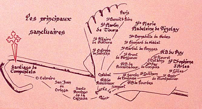
Pilgrims coming from countries other than Portugal or Spain followed four ancient pilgrims routes across France toward Compostela : the Route of Paris, the Route of Vézelay, the Route of Le Puy (Via Podiensis), and the Route of Arles. All along the pilgrimge routes, cathedrals, churches, monasteries, hospitals and chapels—founded by religious orders and backed by rich patrons— contained exquisite and unusual artistic creations. Given the basic life of most people in the middle ages, these edifices were not only for worship and acquiring grace, but were for viewing the art and the architectural masterpieces of the day. We can analogize the religious pilgrimages of a millennium ago, in part, to today’s “pilgrimages” of tourists—to see landscapes, cathedrals, art museums, palaces, and modern architecture .
The Way of Saint James today:
After 600 years of disuse, a rapidly increasing number of pilgrims (now numbering over 100,000 each year), both religious and laic, travel the St. Jacques pilgrimage routes. Of those who pass through France, by far the greatest number use the Route of Le Puy-en-Velay (about 40,000 to 50,000 in 2022 or perhabs about 1000 persons per day in peak season). One reason may be because the first pilgrim to Compostella was the bishop of Le Puy, in 951, but probably also because the Le Puy route is the wildest and most beautiful, and provides the experience and the feeling of a pilgrimage a millennium ago. Very few of these users are on bicycle, perhaps a handful a day.
The “official” walking route from Le Puy to Saint Jean-Pied-de-Port is the GR 65. GR stands for “Grande Randonnée”, which means a long distance walking path. These trails are laid out to avoid traffic, and are waymarked with white over red rectangles. A white arrow indicates turns and an “X” indicates a bad direction. On the Le Puy route they are also indicated by white posts with a red stripe. On routes to Compostella confusion can arise because they are often also marked with pictures of or actual scallop shells. (A scallop in French is a “Coquille [shell] St. Jacques, since scallops came from the Spanish Atlantic coast.) Since the 13th century, pilgrims have often affixed the scallop symbol or actual scallop shells to their clothes. However, today restaurants and other businesses try to attract walkers by marking a scallop trail to their door, often a considerable distance off the walking route.
Even with a mountain bike it can be impractical or impossible to follow the GR65 walking route. In any event, given its many local deviations from the ancient pilgrim route, following the GR65 on a bicycle does not make sense.
To qualify as a pilgrim with the church authorities in Compostela, Spain, you must walk, ride a horse or a mule for 200 kilometers; or a bicycle for 300 kilometers. There is no need to start in France. However, as in ancient times, today many true pilgrims start from their home in European countries often other than France or Spain, and if they cannot devote months to walking or riding, break the trip into segments over several years. While the ancient pilgrims had to walk or ride back to their homes from Compostella, now it is extremely unlikely that you will meet somebody walking or riding in the direction opposite yours.
The thinking behind my bike route:
The cycling route found on this website is laid out to stay close to the ancient pilgrimage route. It does not attempt to follow the GR65 walking route used by almost all Via Podiencis walkers, which sometimes corresponds to the routes used by ancient walkers, sometimes not. My biking route usually follows low traffic roads and lanes that were once the ancient pilgrimage paths, sometimes overlapping the GR65, often not. (I have used maps of the ancient ways included in the now out of print, intellectual 1995 book Le Chemin de St-Jacques, Du Puy-en-Velay à Roncevaux Par le GR 65“).
It is, however, impossible for any route to follow precisely the ancient ways. Ancient bridges have crumbled or washed away; ferries no longer cross broad rivers; roads have disappeared; paths have become national highways. Ancient pilgrims did not always follow one route. Often some detoured to stay in the hills that were safer than the valleys and to avoid the heat. Some detoured to visit somewhat out of the way religious sites, such as Rocamadour. I discuss many of these choices on the pages for each day. Occasionally, when there is a choice between a fast or easy non-athentic route and a slow or difficult authentic route, I offer a choice. The GPX coordinates for each day are for my personally preferred route.
I have chosen the length of each day for what I think is reasonable and what I have ridden, but I mention alternative stopping points, and you will find more in the book Miam Miam Dodo or through your own research. Even if you are using GPS, I suggest that you examine ahead of time the route for the day. This is guaranteed to make route-finding much easier and less error-prone. Should you use GPS Ancient pilgrims did not.
I have done my best to verify and update my previous experience in biking the Via Podensis by using Google roadside views very, very extensively — if you will, making an almost complete virtual pilgrimage in 2022. This has been particularly helpful in exploring a few road changes and a few better alternatives to what I rode in my actual physical tour. I believe the routes on this website will remain valid for a decade or more. But as is always mentioned in these sorts of writings, please check online and locally to confirm what you read here.